The administrative map of Vietnam plays a very important role in many fields, from politics to economy and society. It is a useful tool for resource management, development planning and investment orientation, research and teaching. Let's find out the detailed administrative map of Vietnam with IOTLink through the following article!
Table of contents
ToggleAdministrative map of Vietnam
Administrative map is a thematic map with professional elements showing the division of territory and management of administrative units according to the regulations of the State of Vietnam. (According to Clause 1, Article 3 of Circular 47/2014/TT-BTNMT)
Administrative map of Vietnam showing the administrative area of 63 cities. Along with 3 North - Central - South regions and 7 economic regions.
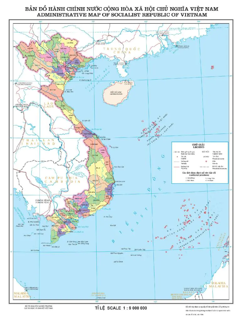
Administrative map of North - Central - South
Administrative map of the North
North Vietnam is considered the "heart of the country". Hanoi is the political, economic and cultural center. The North is divided into three key economic regions based on the natural topography and economic development characteristics.
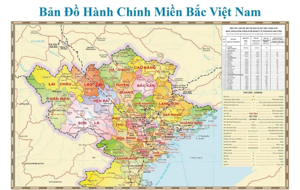
- The Northwest consists of 6 provinces: Hoa Binh, Dien Bien, Son La, Lao Cai, Lai Chau and Yen Bai.
- The Red River Delta consists of 10 provinces and cities: Hanoi, Ha Nam, Bac Ninh, Ninh Binh, Hai Phong, Hai Duong, Nam Dinh, Hung Yen, Thai Binh and Vinh Phuc.
- The Northeast consists of 9 provinces and cities: Ha Giang, Cao Bang, Lang Son, Bac Can, Thai Nguyen, Tuyen Quang, Bac Giang, Phu Tho and Quang Ninh.
Central administrative map
The provinces in Central Vietnam are divided into 3 smaller economic regions.
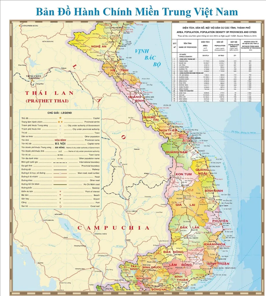
- North Central region includes 6 provinces: Thanh Hoa, Ha Tinh, Nghe An, Quang Tri, Quang Binh and Thua Thien - Hue.
- The Central Highlands is the largest plateau in our country with 5 provinces stretching from North to South: Gia Lai, Kon Tum, Dak Nong, Dak Lak and Lam Dong.
- The South Central Coast and Central Central Coast include 8 provinces: Ninh Thuan, Binh Thuan, Khanh Hoa, Quang Ngai, Quang Nam, Da Nang, Binh Dinh and Phu Yen.
Administrative map of the South
The South consists of two major economic regions, the Southeast and the Southwest. These two regions have potentials for economic development. Create initiative for the development of the whole southern region of the country.
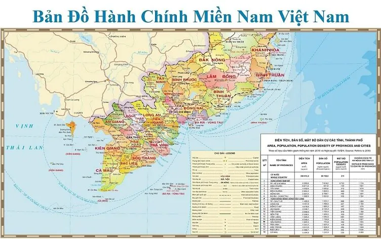
- The Southeast (Eastern region) includes 1 city and 5 provinces: TP. Ho Chi Minh City, Binh Duong, Binh Phuoc, Dong Nai, Ba Ria - Vung Tau and Tay Ninh.
- The Southwest region (Mekong Delta region) includes Can Tho (central city) and 12 provinces: Long An, Tien Giang, Vinh Long, Tra Vinh, Soc Trang, Hau Giang, Dong Thap, An Giang , Kien Giang, Ben Tre, Bac Lieu and Ca Mau.
How to view the map of Vietnam
Paper map
- Map scale: The ratio between the distance measured on the map and the distance measured in real life. Shows the degree of reduction on the image. The larger this ratio, the clearer and more detailed the content is, and vice versa.
- Contour line: A contour line consisting of many wavy circles. Used on maps with 2D images for the purpose of depicting elevations at ground level.
- Symbols and annotations: The footnotes section also shows some information related to that version. Characters, symbols, lines, and colors represent different objects and positions.
Map4D . Digital Map
With just a few simple steps, you can view the map of Vietnam on the Map4D application.
Download the Map4D app
Search for the place you want to know. Map4D application always updates information regularly. Bring you the best user experience.
The importance of the administrative map of Vietnam
The administrative map of Vietnam is of great importance for many different fields.
Land and resource management
It is an important tool for authorities to locate, locate, classify and manage different types of land and resources.
Development planning and investment orientation
Useful in development planning and investment orientation in different administrative units in the territory of Vietnam. The authorities can rely on the map to assess development potential, identify priority areas and plan socio-economic development.
Support address search
Support for finding addresses becomes easier. Determine the geographical location of different locations in the territory of Vietnam. From there easily search and move to the desired location.
In education, teaching and learning
It is a useful tool in teaching and learning. Especially in subjects related to geography, history and politics. Teachers and students can easily learn about different administrative units in the territory of Vietnam. Learn the basics of the geography, population, economy, and politics of these units.
Scientific research
The map plays an important role in scientific research and development orientation of many different fields. Thanks to it, researchers can collect information, analyze and evaluate socio-economic indicators of different administrative units in the territory of Vietnam. This helps to come up with effective socio-economic development solutions that are suitable to local realities.
Population management and statistics
Based on this map to determine population, population distribution, population counting and other statistical work.
Road and traffic management
The administrative map of Vietnam is also a tool that the authorities. This tool can be relied on for traffic assessment, route allocation and transport infrastructure development planning.
In short
In summary, the administrative map of Vietnam shows the administrative division of 63 cities. Along with 3 North - Central - South regions and 7 economic regions. It is of great importance in many different fields. Therefore, maintaining and updating the administrative map of Vietnam is always considered very important and necessary.
