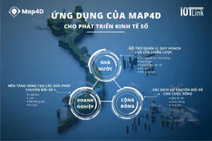
In the context that the whole country is promoting digital transformation, building a smart city is a goal in urban infrastructure planning and management. Map4D in urban infrastructure planning and management provides complete and accurate data on the basis of a combination of 2D and 3D maps in real time, promoting the fast and efficient construction of smart cities. results, meeting the modern life of people as well as the general development of the whole society.
Table of contents
ToggleWhat is Map4D?
Map4D is the first and only digital map in Vietnam using real-time 3D and 4D maps. In other words, Map4D provides 3D images under an intuitive, vivid coordinate system, helping users see the change of an object over time.
>>> See more MAP4D – DIGITAL TECHNOLOGY ERA
What is urban planning?
Urban planning is the organization of space, architecture, urban landscape, system of technical infrastructure works, social infrastructure works and houses. To create a suitable living environment for people living in urban areas. Expressed through urban planning projects.
Urban planning helps socio-economic development of the whole country, a region, province, district or region.
What is urban technical infrastructure?
Urban technical infrastructure is a collection of design and construction works, technical equipment of urban areas - urban transport systems, supply of domestic water, surface water drainage, and dirty water drainage. , power supply, communication lines, gas supply, waste and manure treatment... These technical equipment systems are intended to ensure comfort in the living and production of the community.
Map4D in planning and managing urban infrastructure efficiently and cost-effectively
With modern technology integrated in Map4D such as AI, VR, AI, IoT, Machine Learning... Analysis is based on many layers of data, providing all necessary parameters in planning.
Intuitive, detailed 3D images thanks to the VR 360 app and Smart Camera. Helping analysts and investors have an overview of the planned area. From there, the right development direction. Map4D gathers data, deeply analyzes information and returns results to serve urban infrastructure planning and management activities towards smart city development.
- Residential residential area
- Office commercial area
- Retail mall or highway complex
- The industrial zone has factories and heavy industry production units
- Farmland for farming
- Public and semi-public land in infrastructure development
- Public parks and playgrounds, green open spaces
- Mixed land for urbanization development
Going deep and closely with the support of digital maps for each of the above specific activities, making the planning and management process simpler and more effective.
Step by step building and developing smart city
Smart city is the higher goal of urban planning. And has been clearly outlined by the Government in the digital transformation. To achieve the goal, effective application of technology is a prerequisite.
Map4D allows for quick information retrieval. Just through a few simple steps on Smartphone or PC. Maximum support in data management and analysis activities.
Images are taken at every location from outdoor space to every corner of a building using 3D images to support zoning and urban planning for good land management. At the same time, based on the planned zoning plan, the Government can prevent rampant construction, loss of control as well as illegal profiteering.
Via Map4D, the database of works. Such as construction, transportation system, technical infrastructure, trees, sewer system, etc. are fully displayed in an authentic way. Collected and analyzed results from Map4D are an effective "advisor" to support the Government and Investors in urban planning and management towards smart city development.
The application of information technology, typically Map4D, in urban planning has become a trend. Accurately and effectively apply towards building and developing smart city. That is the goal of all levels of government. This is the driving force behind socio-economic development.