Vietnam map 3 regions help you better understand the geography of the country Vietnam. Vietnam has 3 regions: North, Central and South. Each region has its own characteristics in terms of topography, climate, culture and history. Join IOTLink to learn about Vietnam's 3 regions map in this S-shaped country!
Geographical location of Vietnam
Vietnam is located on the eastern edge of the Indochinese peninsula, in Southeast Asia.
- To the north, it borders China.
- The West borders Laos and Cambodia.
- The East and the South are bordered by the East Sea.
- Vietnam's waters are adjacent to the waters of the following countries: China, the Philippines, Malaysia, Cambodia, Brunei, Indonesia, and Thailand.
The territory of Vietnam is a unified and complete block. Consists of land, sea and airspace.
The land of Vietnam
Vietnam with an area of 331,212 km² (according to 2006 statistics).
The land border is 4600km long and the coastline is 3200km long.
There are more than 4000 large and small islands, Hoang Sa Islands (Da Nang City), Truong Sa Islands (Khanh Hoa province).
Sea of Vietnam
The sea area is about 1 million km². Adjacent to the waters of 8 countries. Including: internal waters, territorial sea, contiguous zone, exclusive economic zone, continental shelf area.
Vietnam's airspace
The space that covers the territory of Vietnam. On land it is defined by borders. At sea is the outer boundary of the territorial sea and the space of islands.
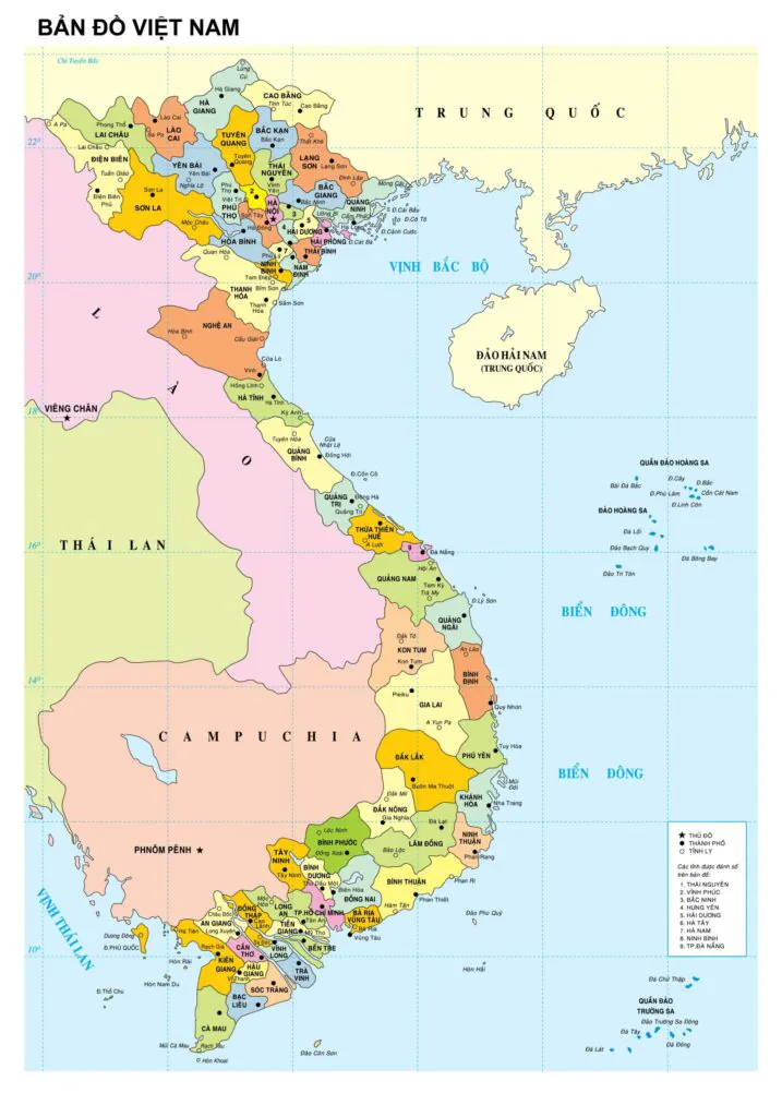
Map of Vietnam 3 regions North - Central - South
Administrative map of Vietnam
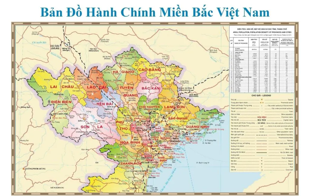
Administrative map of the North
- Northeast: Ha Giang, Bac Can, Cao Bang, Tuyen Quang, Lang Son, Thai Nguyen, Bac Giang, Phu Tho, Quang Ninh.
- Northwest: Lao Cai, Dien Bien, Yen Bai, Lai Chau, Hoa Binh, Son La.
- Red River Delta: Hanoi, Bac Ninh, Hai Duong, Ha Nam, Hai Phong, Nam Dinh, Hung Yen, Thai Binh, Ninh Binh, Vinh Phuc.
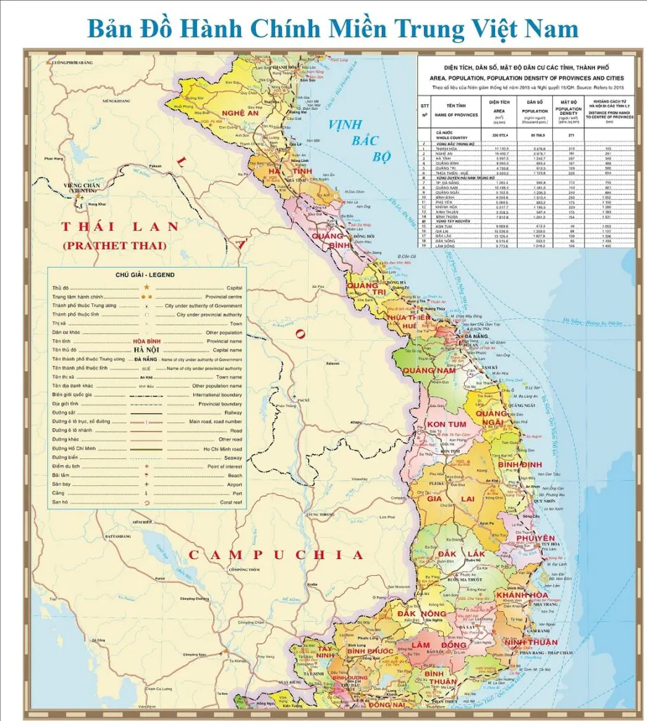
Administrative map of the Central region
- North Central: Nghe An, Thanh Hoa, Ha Tinh, Quang Tri, Quang Binh and Thua Thien - Hue.
- South Central Coast: Khanh Hoa, Binh Thuan, Ninh Thuan, Quang Nam, Quang Ngai, Da Nang, Binh Dinh and Phu Yen
- Central Highlands: Kon Tum, Gia Lai, Dak Nong, Dak Lak and Lam Dong.
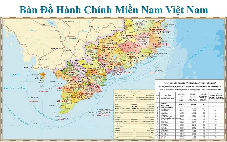
Administrative map of the South
- Southeast region: Binh Duong, Binh Phuoc, Tay Ninh, Dong Nai, Ba Ria - Vung Tau and Ho Chi Minh City.
- Southwest region: Long An, Dong Thap, An Giang, Tien Giang, Ben Tre, Tra Vinh, Vinh Long, Kien Giang, Hau Giang, Bac Lieu, Soc Trang, Ca Mau, Can Tho city.
Traffic map of Vietnam
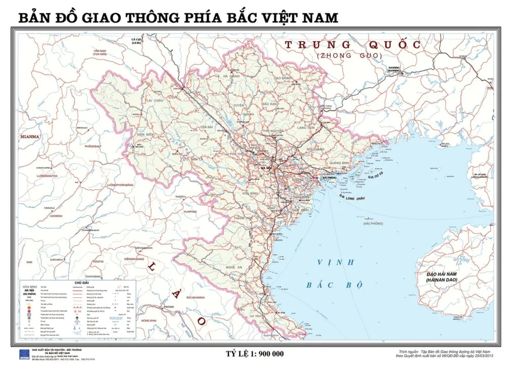
Northern traffic map
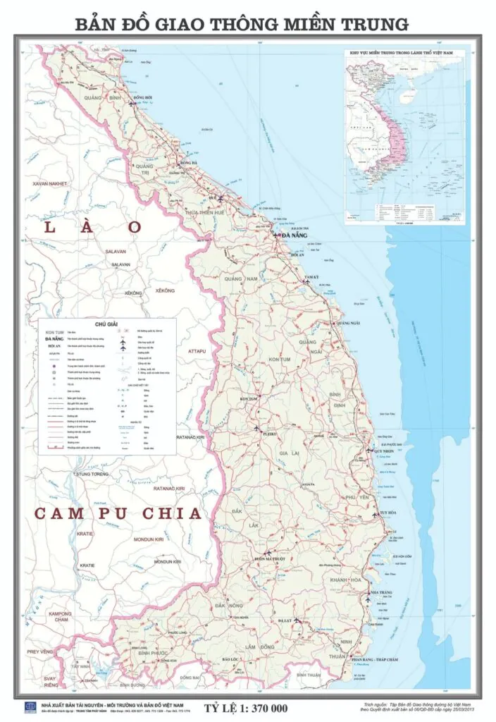
Central traffic map
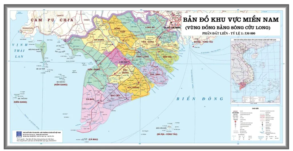
Southern traffic map
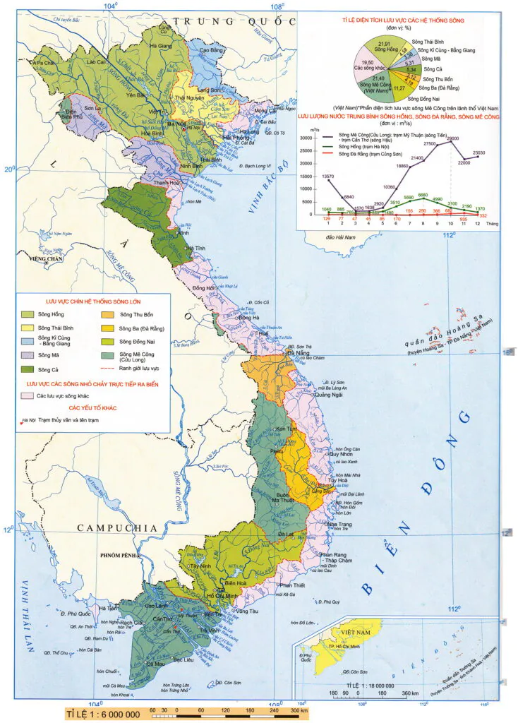
Vietnam river map
Vietnam is a country with a dense and rich network of rivers, which are widely distributed throughout the country.
According to statistics, our country has 9 major river systems stretching from North to South. In which there are about 2360 rivers and canals large and small.
There are 9 major river systems including: Red River, Ma River, Thai Binh River, Ky Cung River - Bac Giang, Thu Bon River, Ba River, Ca River, Dong Nai River, Mekong River and other river basins flowing directly to the sea.
Large river systems often originate from outside into the territory of Vietnam. These large river systems bring fertility to the delta every year.
Population density map in Vietnam
Vietnam's population information is provided on the Population and Development Spatial Data System. Accessible to the address http://gis.gso.gov.vn
This data will be continuously updated every year to inform researchers and policy makers important data about population and population's geographical location related to economic issues. , society and environment.
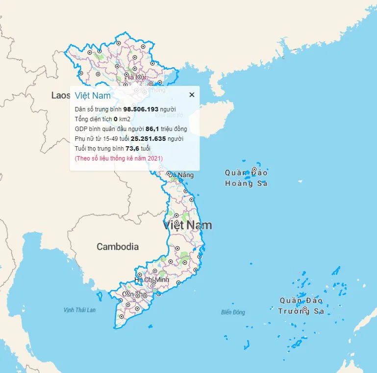
- According to the latest data from the United Nations updated on April 25, 2023, the current population of Vietnam is 99,562,877 people.
- Vietnam's population currently accounts for 1,24% of the world's population.
- Vietnam is ranked 15th in the world
- The population density of Vietnam is 321 people/km² . with a total land area of 310,060 km².
- The population living in urban areas is 38,77%.
- The average age is 33.7 years old.
Map of key economic zones in Vietnam
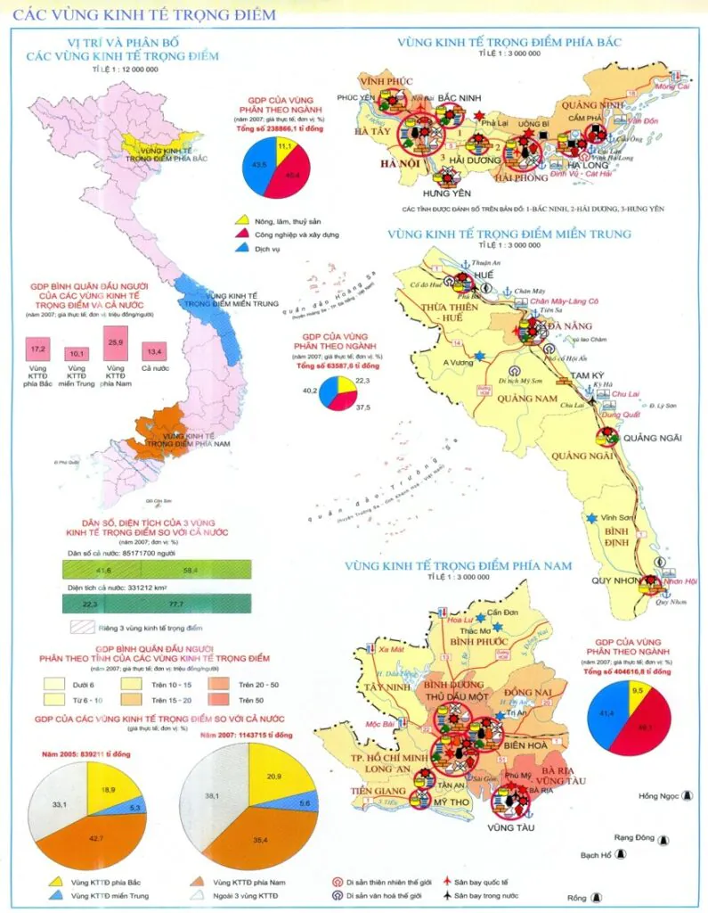
Northern key economic region
The Northern key economic region includes 7 provinces and cities: Hanoi, Hai Phong, Quang Ninh, Hai Duong, Hung Yen, Bac Ninh and Vinh Phuc.
- The Northern key economic regions have many strengths for economic development and exchange.
- Convenient geographical location, developed infrastructure.
- A place with a long history, famous traditional industries, a diversified structure soon developed.
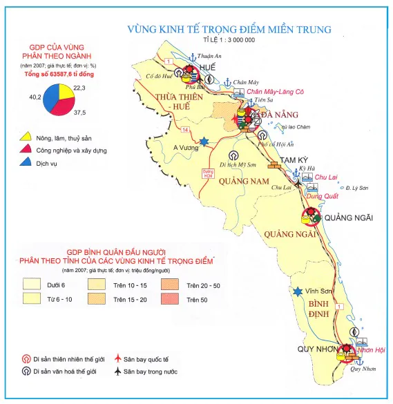
Central key economic region
The central key economic region includes: Da Nang, Thua Thien - Hue province, Binh Dinh, Quang Nam, and Quang Ngai.
The leading strength of the central key economic region is the integrated exploitation of marine, forest and mineral resources.
- Planting forests in the western mountains
- Mining minerals (gold, tin).
- The midland hills are easy to develop agro-forestry models
- Planting industrial crops, fruit trees and raising livestock.
- The coastal plain area develops food crops and exploits the marine economy.
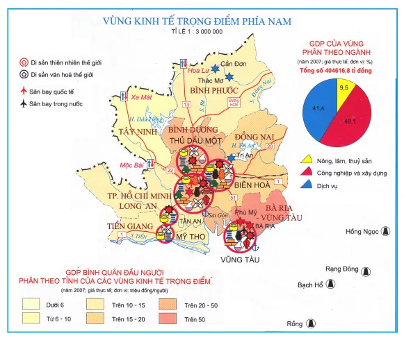
Southern key economic region
The southern key economic region includes 8 provinces and cities. Includes: City. Ho Chi Minh City, Binh Phuoc, Binh Duong, Tay Ninh, Dong Nai, Ba Ria - Vung Tau, Long An and Tien Giang.
Abundant natural resources. Especially gas and oil.
The southern key economic region can be strong in exploiting three natural resources: minerals, sea and forests.
- The area is densely populated and has an abundant workforce.
- High level of expertise and production organization.
- The strong investment in facilities helps the southern key economic region to develop immensely.
In short
Overview of maps of Vietnam in 3 regions that IOTLink has shared knowledge with readers for reference. Different types of maps represent different information. Each domain will have its own characteristics and the map will clearly show those elements. Using maps can help you in your research and study.
Also, if you use maps for navigation and directions, quickly download the Map4D application to your phone so you can go where you want to go!


Thông tin này rất quý, rất bổ ích cho mọi người…
Thank you for supporting IOTLink's Map4D.
We hope to continue to receive your interest.
Wish you a happy new day!